

Utility Software
Cloud and Shadow Mask Utility
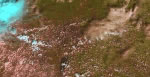 Clouds in remote sensing images are a source of information in different ways. Clouds play a critical role in the climate system and have importance in the energy balance of the atmosphere. Cloud cover can also provide information related to weather conditions and predictions. In Optical remote sensing the data acquired is affected by the presence of cloud. For studying land resources, the clouds block the features beneath it. In such cases, information on cloud pixels is a necessity for feature extraction. Delineation of clouds and cloud shadows is an important pre-processing step. Any reliable cloud delineation algorithm makes use of thermal band in addition to visible bands. In the absence of thermal band for Resoursesat-2 AWiFS images, an algorithm based on unsupervised classification exploiting spectral attributes is developed for automatic cloud and cloud shadow detection. (1) Download (2) User Manual
SWIR Band synthesis utility for IRS Resourcesat-2 LISS-4 Mx Data
 SWIR band finds its uses in many applications (snow and cloud detection etc.), Resourcesat Series satellites carry LISS-4 sensor which provides data at a spatial resolution of 5.8m in 4, 3, 2 bands. The SWIR band of in LISS-4 is synthesized using the spatial and spectral knowledge from LISS-3. This module generates synthesized SWIR band at a spatial resolution of LISS-4, by taking the inputs as LISS-3 (Layer stacked as B234), LISS-4 (Layer stacked as B2345) images along with their Meta files. The module accepts inputs in Geo-Tiff format and provides output in Geo-Tiff format. The S/W module has been developed using the coefficients derived from spectral transformation method to establish a relationship between B234 and B345 of LISS-3 image and applying these coefficients on B234 of LISS-4 Image to derive synthesized SWIR band. (1) Download (2) User Manual.
Resourcesat-2 HDF to GeoTiff conversion Utility
 HDF stands for Hierarchical Data Format. HDF5 is a library and multi object file format for storing scientific data. HDF5 is a completely new Hierarchical Data Format, consisting of a data format specification and a supporting library implementation. It is freely available and designed to address some of the limitations of the older HDF format and also to address current and anticipated requirements of modern systems and applications. Two versions of HDF are currently in widespread use: HDF4 and HDF5. HDF5 is adopted as one of the formats for product dissemination from ISRO's earth observation satellite RESOURCESAT-2.The HDF to GeoTiff Conversion utility developed to allow a user to convert HDF5 Level 2 RAD/Geo data products for RESOURCESAT-2 AWiFS, LISS3, LISS4 (Mono, Mx modes) sensors into GeoTiff format to facilitate users to use these data in other applications which does not support HDF. (1) Download 32 Bit Linux Version. (2) Download 64 Bit Linux Version. (3) Download 32 Bit Windows Version. (4) Download 64 Bit Windows Version. (5) User Manual.


