

Utility Software
Image Mosaicing Utility
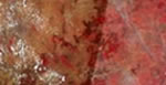 Image mosaicing is an important step in generation of large area radiometrically balanced images for mapping applications as well as in visualisation of large areas in a single view. Mosaicking is the process of joining overlapped georeferenced images together to form a larger image. Mosaic of multiple images involves two major steps color balancing and stitching. Many color matching techniques are available, but no single color matching technique is suitable for a given set of images. In this tool, Mosaic Normalization is achieved using statistical based automated tool to color match 'N' number of images and to get seamless mosaic with 'cut line feathering technique' in overlap areas. It assumes both images (to be mosaiced) are geometrically registered and have certain overlap and they are at the same spatial resolution. (1) Download (2) User Manual.
Semi- Automatic Registration utility for Resourcesat Imagery
 Semi-Automatic registration tool is developed to rectify the Resourcesat images using polynomial transformation. This utility is designed using the object-oriented approach with an objective of high performance and with user-friendly functionalities for generating the registered images with respect to reference images. It has capability of using multiple processors for efficient image processing. This module is developed on JAVA and generates automatic tie points and also provides display viewer for delete, modify and adding the control points. This module provides basic image viewing options like panning, zooming, scrolling. The module supports various re-sampling techniques viz., Nearest Neighborhood, bilinear and cubic convolution. (1) Download (2) User Manual.
Utility for Mapping of SOI Map series to Open series Maps
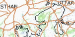 The main purpose of the utility is to assist the users in relating Open Series Maps (OSM) to old Toposheets or vice versa. These Toposheets were printed by survey of India on 1:250,000; 1:50,000 and 1:25,000 scales. Old Topographic maps are based on Everest Datum and Polyconic Projection. The new OSM maps are based on UTM, WGS-84 datum. The Toposheet Conversion utility has a graphical user interface (GUI) which uses Java Swing technology. (1) Download (2) User Manual.


